Sunday 23 October 2016

Komodo (Island)

Komodo is one of the 17,508 islands that compose the Republic of Indonesia. The island is particularly notable as the habitat of the Komodo dragon, the largest lizard on Earth, which is named after the island. Komodo Island has a surface area of 390 square kilometres and a human population of over two thousand. The people of the island are descendants of former convicts who were exiled to the island and who have mixed with Bugis from Sulawesi. The people are primarily adherents of Islam but there are also Christian and Hindu congregations.
Komodo is part of the Lesser Sunda chain of islands and forms part of the Komodo National Park. In addition, the island is a popular destination for diving. Administratively, it is part of the East Nusa Tenggara province.

Description

Komodo is part of the Lesser Sunda chain of islands and forms part of the Komodo National Park. It lies between the substantially larger neighboring islands Sumbawa to the west and Flores to the east. The island's surface area covers 390 square kilometres.

History

The earliest stories of a dragon existing in the region circulated widely and attracted considerable attention. But no one visited the island to check the story until official interest was sparked in the early 1910s by stories from Dutch sailors based in Flores in East Nusa Tenggara about a mysterious creature. The creature was allegedly a dragon which inhabited a small island in the Lesser Sunda Islands (the main island of which is Flores).

Vegetation on Komodo Island
The Dutch sailors reported that the creature measured up to seven metres (twenty-three feet) in length with a large body and mouth which constantly spat fire. Hearing the reports, Lieutenant Steyn van Hensbroek, an official of the Dutch Colonial Administration in Flores, planned a trip to Komodo Island. He armed himself, and accompanied by a team of soldiers he landed on the island. After a few days, Hensbroek managed to kill one of the lizards.
Van Hensbroek took the dragon to headquarters where measurements were taken. It was approximately 2.1 metres (6.9 feet) long, with a shape very similar to that of a lizard. More samples were then photographed by Peter A. Ouwens, the Director of the Zoological Museum and Botanical Gardens in Bogor, Java. The records that Ouwens made are the first reliable documentation of details about what is now called the Komodo dragon (or Komodo monitor).
Ouwens was keen to obtain additional samples. He recruited hunters who killed two dragons measuring 3.1 metres and 3.35 metres as well as capturing two pups, each measuring less than one metre. Ouwens carried out studies on the samples and concluded that the Komodo dragon was not a flame-thrower but was a type of monitor lizard. Research results were published in 1912. Ouwens named the giant lizard Varanus komodoensis. Realizing the significance of the dragons on Komodo Island as an endangered species, the Dutch government issued a regulation on the protection of the lizards on Komodo Island in 1915.
The Komodo dragon became something of a living legend. In the decades since the Komodo was discovered, various scientific expeditions from a range of countries have carried out field research on the dragons on Komodo Island.
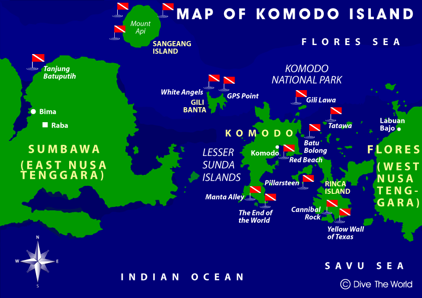
Pulau Komodo adalah sebuah pulau yang terletak di Kepulauan Nusa Tenggara. Pulau Komodo dikenal sebagai habitat asli hewan komodo. Pulau ini juga merupakan kawasan Taman Nasional Komodo yang dikelola oleh Pemerintah Pusat. Pulau Komodo berada di sebelah timur Pulau Sumbawa, yang dipisahkan oleh Selat Sape.
Secara administratif, pulau ini termasuk wilayah Kecamatan Komodo, Kabupaten Manggarai Barat, Provinsi Nusa Tenggara Timur, Indonesia. Pulau Komodo merupakan ujung paling barat Provinsi Nusa Tenggara Timur, berbatasan dengan Provinsi Nusa Tenggara Barat.
Di Pulau Komodo, hewan komodo hidup dan berkembang biak dengan baik. Hingga Agustus 2009, di pulau ini terdapat sekitar 1300 ekor komodo. Ditambah dengan pulau lain, seperti Pulau Rinca dan dan Gili Motang, jumlah mereka keseluruhan mencapai sekitar 2500 ekor. Ada pula sekitar 100 ekor komodo di Cagar Alam Wae Wuul di daratan Pulau Flores tapi tidak termasuk wilayah Taman Nasional Komodo.
Selain komodo, pulau ini juga menyimpan eksotisme flora yang beragam kayu sepang yang oleh warga sekitar digunakan sebagi obat dan bahan pewarna pakaian, pohon nitak ini atau sterculia oblongata di yakini berguna sebagai obat dan bijinya gurih dan enak seperti kacang polong.
Pulau Komodo juga diterima sebagai Situs Warisan Dunia UNESCO, karena dalam wilayah Taman Nasional Komodo, bersama dengan Pulau Rinca, Pulau Padar dan Gili Motang

Sejarah

Pada tahun 1910 orang Belanda menamai pulau di sisi selatan Provinsi Nusa Tenggara Timur ini dengan julukan Pulau Komodo. Cerita ini berawal dari Letnan Steyn van Hens Broek yang mencoba membuktikan laporan pasukan Belanda tentang adanya hewan besar menyerupai naga di pulau tersebut. Steyn lantas membunuh seekor komodo tersebut dan membawa dokumentasinya ke Museum and Botanical Garden di Bogor untuk diteliti.
Tahun 2009, Taman Nasional Komodo dinobatkan menjadi finalis "New Seven Wonders of Nature" yang baru diumumkan pada tahun 2010 melalui voting secara online di www.N7W.com.Pada tanggal 11 November 2011, New 7 Wonders telah mengumumkan pemenang sementara, dan Taman Nasional Komodo masuk kedalam jajaran pemenang tersebut bersama dengan, Hutan Amazon, Teluk Halong, Air Terjun Iguazu, Pulau Jeju, Sungai Bawah Tanah Puerto Princesa, dan Table Mountain. Taman Nasional Komodo mendapatkan suara terbanyak.


Lanikai Beach

Lanikai Beach is located in Lanikai, a community in the town of Kailua and on the windward coast of Oahu, Hawaii. The name Lanikai means "heavenly sea." This small ½ mile strip of beach is consistently ranked among the best beaches in the world. Adjacent to Lanikai Beach is a primarily upper-class residential area because of this it is accessible through public beach access paths. Although the beach itself is public property, it is not state land and is not a county beach park like many beaches in Hawaii. There is no public parking lot and the area lacks facilities like restrooms, showers or lifeguards.As of July 1, 2014, parking violation fines have increased from $35 to $200 in an effort to keep people from illegally parking in the residential area surrounding the beach accesses.
During the weekdays, the beach is less crowded compared to the weekends, although it is still very difficult to find parking close to one of the public beach accesses. On weekends, the beach becomes extremely crowded and during vacation seasons such as winter and summer, the beach is almost completely packed every single day. Lanikai is a popular spot for photo shoots as renowned models and photographers frequent the place on nice days. What makes Lanikai Beach popular for photographers is having the two Islands in the background called the Na Mokulua or "mokes". Kayakers will often row out to land on the larger northern island, but no one is allowed to land on the southern island as it is a bird sanctuary. Water temperatures are generally 75–80 °F (24–26 °C) so you can spend plenty of time in the water. It has extremely soft powdery clean white sand. Lanikai Beach is regularly voted as one of the best beaches in America and is the only beach in the USA that was voted as one of the best beaches in the world.
Due to its position on the Windward or east side of the island, Lanikai is recognized as being great place to watch the moonrise over the Mokuluas, especially during the full moon. Occasionally during the year the sun will rise directly between the Na Mokulua islands.

Hawai selalu indentik dengan kehidupan serba santai di pantai dengan keindahan alam dan nyiur melambai. Gambaran itu tidaklah salah dan bisa Anda temukan di pantai Lanikai. Lanikai adalah pantai yang nyaris tak bisa dijelaskan hanya dalam satu kalimat. Disinilah tanaman khas tropis tumbuh subur menghiasi birunya laut dan langit. Sinar matahari seolah tak berujung, bersinar dan menemani para wisatawan yang asyik berjemur. Perpaduan ini semua membuat Lanikai disebut sebagai pantai paling indah di Hawai.

Perairannya sangat bersih dan luas. Hamparan pasir putihnya bagaikan permadani yang mengundang siapapun untuk duduk menikmati ombak yang datang dan pergi. Di sisi lainnya, Lanikai ramai oleh para turis yang bermain air seperti mencoba kayak atau surfing.  Uniknya, Lanikai tak hanya menyediakan keindahan pantai ini saja tetapi juga pulau-pulau terdekat. Anda bisa menumpang kayak untuk mengunjungi gugusan pulau yang tak jauh dari pantai ini. Tak heran jika Lanikai sangat populer diantara turis-turis yang menyukai kegiatan kayaking dan surfing. Pada akhir pekan, Lanikai riuh oleh pengunjung yang piknik dan berenang. Pantai ini juga bisa dijadikan tujuan destinasi keluarga karena sanga cocok untuk anak-anak kecil.

Dalam dialek Hawai, “Lanikai” berarti “laut surgawi”. Hal itu tak berlebihan karena tempat ini begitu digandrungi oleh wisatawan mancanegara, domestik maupun warga setempat. Barangkali karena letaknya berdekatan dengan kompleks mewah pemukiman warga membuat suasana pantai dan gaya hidup metropolis berpadu. Pantai ini juga menjadi tempat yang sering digunakan sebagai lokasi photo session. Tidak hanya itu karena berada di sebelah timur kepulauan, Lanikai adalah tempat yang sempurna untuk melihat indahnya bulan purnama.
Untuk datang ke tempat ini tidaklah sulit, Anda cukup mengarahkan kemudi dari Waikiki menuju Pali Highway. Sesampainya di Pali ambilah ruas jalan yang mengarah ke Windward Oahu. Selain Lanikai, isi perjalanan Anda dengan mengunjungi teluk Hanauma, Lahaina dan Panaewa Rainforest Zoo.


Horseshoe Bay, Texas

Horseshoe Bay is a city in Llano and Burnet counties in the U.S. state of Texas. Prior to its incorporation in September 2005, it was a census-designated place (CDP). The CDP population was 3,337 at the 2000 census. The 2010 census put the population at 3,418.

Geography

Horseshoe Bay is located at 30°32′41″N 98°22′06″W (30.544814, -98.368428).It is located in primarily in Llano County and extends eastward into Burnet County, on the southern shore of Lake Lyndon B. Johnson. It is about 28 miles (45 km) southeast of Llano and 51 miles (82 km) northwest of downtown Austin.
According to the United States Census Bureau, the city has a total area of 11.6 square miles (30.1 km2), of which 11.4 square miles (29.5 km2) is land and 0.23 square miles (0.6 km2), or 1.83%, is water.

Demographics

Historical population
CensusPop.
20103,418
Est. 20153,560[7]4.2%
U.S. Decennial Census[8]
As of the census of 2000, there were 3,337 people, 1,623 households, and 1,186 families residing in the CDP. Thepopulation density was 142.8 people per square mile (55.1/km2). There were 2,773 housing units at an average density of 118.7/sq mi (45.8/km2). The racial makeup of the CDP was 96.22% White, 0.33% African American, 0.24% Native American, 0.78% Asian, 1.47% from other races, and 0.96% from two or more races. Hispanic or Latino of any race were 4.29% of the population.
There were 1,623 households out of which 11.6% had children under the age of 18 living with them, 68.5% weremarried couples living together, 2.8% had a female householder with no husband present, and 26.9% were non-families. 24.0% of all households were made up of individuals and 12.1% had someone living alone who was 65 years of age or older. The average household size was 2.06 and the average family size was 2.37.
In the CDP the population was spread out with 10.6% under the age of 18, 3.4% from 18 to 24, 15.0% from 25 to 44, 36.2% from 45 to 64, and 34.8% who were 65 years of age or older. The median age was 58 years. For every 100 females there were 95.7 males. For every 100 females age 18 and over, there were 95.7 males.
The median income for a household in the CDP was $54,073, and the median income for a family was $65,324. Males had a median income of $39,375 versus $23,019 for females. The per capita income for the CDP was $36,254. About 5.8% of families and 6.1% of the population were below the poverty line, including 9.2% of those under age 18 and 4.7% of those age 65 or over.

Education

The Llano County portion of Horseshoe Bay is served by the Llano Independent School District. The Burnet County portion is served by the Marble Falls Independent School District.


Flamenco Beach

Flamenco Beach is a public beach on the Caribbean island of Culebra (Spanish pronunciation: [koo-LAI-brah]). It is known for its shallow turquoise waters, white sand, swimming areas, and diving sites. It stretches for a mile around a sheltered, horseshoe-shaped bay. Playa Flamenco is a popular beach destination for both Culebra and Puerto Rico. In March 2014, Flamenco beach was ranked 3rd best beach in the world with a TripAdvisor Travelers' Choice Award.In August 2016, it was announced that Flamenco Beach had regained its Blue Flag Beach international distinction. 

Tourism


Flamenco Beach is the top ranked beach in Puerto Rico and one of the top beaches in the world. The beach has available lifeguard towers, kiosks selling food, beach accessories, and easy access from the town of Dewey(where the ferry boat arrives).

Geography

Flamenco is located on the northern shore of Culebra. The beach lies on a half-mile-wide, horseshoe strip of coast. The beach is bordered by the Culebra National Wildlife Refuge, which is of itself one of the oldest wildlife preserves in the United States. Off the coast of Flamenco, approximately a quarter-mile, is a reef where the surf breaks. Characteristic of Flamenco is the beach's white sand and shallow clear waters.

Flora and fauna

The waters off Flamenco beach are home to species of parrot fish, blue tang, multiple species of wrasse and other Caribbean sea fish species. Crustacean species such as Ghost Crab are also observed. Some 50,000 seabirds visit Culebra’s Flamenco Peninsula each summer to nest—mostly sooty terns and other migratory species. Summer visitors to Flamenco Beach are familiar with them as they often feed in the area in large numbers. By September, the birds have gathered up their broods and flown out to sea only to return home the following summer. Occasionally, leatherback and hawksbill sea turtles may be seen as the beaches of the Culebra archipelago are also a major breeding ground for them and the adjacent sea grass beds provide shelter and food for green sea turtles.[15]

Rusting tanks

Rusty Sherman Tank on Flamenco Beach
One of the most distinctive views of the beach include two rusting carcasses of old Sherman Tanks that were left behind by United States Navy in 1975, when they left after using it as weapons testing ground for more than 30 years. While the salty sea winds worked on the metal, causing it to rust and crumble, the locals got to work on decorating them, covering the abandoned hulks in layers of graffiti. Today the tanks remain and have become a unique feature of the otherwise pristine beach. New pieces of graffiti are continually added atop the old, giving the old war machines an almost cheerful new life.


Boracay Phillipines

Boracay is a small island in the Philippines located approximately 315 km (196 mi) south of Manila and 2 km off the northwest tip of Panay Island in Western Visayas region of the Philippines. Boracay Island and its beaches have received awards from numerous travel publications and agencies.[Note 1] The island comprises the barangays of Manoc-Manoc, Balabag, and Yapak in the municipality of Malay, in Aklan Province. The island is administered by the Philippine Tourism Authority and the provincial government of Aklan. Apart from its white sand beaches, Boracay is also famous for being one of the world's top destinations for relaxation.[11][12] It is also emerging among the top destinations for tranquility and nightlife.[13]
In 2012, Boracay was awarded as the best island in the world from the international travel magazine Travel + Leisure.[14][15]
In 2016, the resort island has been named as the Best Island in the World in the 2016 Readers’ Choice Awards of international magazine Condé Nast Traveler.

Geography[edit]


Location of Boracay abovePanay Island.

Puka Beach on the northern shore of Boracay
Boracay Island is located off the northwest corner of Panay Island, and belongs to the Western Visayas island-group, or Region VI, of the Philippines. The island is approximately seven kilometers long, dog-bone shaped with the narrowest spot being less than one kilometer wide, and has a total land area of 10.32 square kilometers.
South-facing Cagban Beach is located across a small strait from the jetty port at Caticlanon Panay island, and the Cagban jetty port serves as Boracay's main entry and exit point during most of the year. When wind and sea conditions dictate, east-facing Tambisaan Beach serves as an alternative entry and exit point.[27] Boracay's two primary tourism beaches, White Beach and Bulabog Beach, are located on opposite sides of the island's narrow central area. White Beach faces westward and Bulabog Beach faces eastward. The island also has several other beaches.
White Beach, the main tourism beach, is about four kilometers long and is lined with resorts, hotels, lodging houses, restaurants, and other tourism-related businesses. In the central portion, for about two kilometers, there is a footpath known as the Beachfront Path separating the beach itself from the establishments located along it. North and south of the Beachfront Path, beachfront establishments do literally front along the beach itself. Several roads and paths connect the Beachfront Path with Boracay's Main Road, a vehicular road which runs the length of the island. At the extreme northern end of White Beach, a footpath runs around the headland there and connects White Beach with Diniwid Beach.
Bulabog Beach, across the island from White Beach, is the second most popular tourism beach on the island and Boracay's main windsurfing and kiteboarding area.
Boracay is divided for land use and conservation purposes into 400 hectares of preserved forestland and 628.96 hectares of agricultural land.


Bali

Bali (Balinese: ᬩᬮᬶ) is an island and province of Indonesia. The province includes the island of Bali and a few smaller neighbouring islands, notably Nusa Penida, Nusa Lembongan, and Nusa Ceningan. It is located at the westernmost end of the Lesser Sunda Islands, between Java to the west and Lombok to the east. Its capital,Denpasar, is located in the southern part of the island.
With a population of 3,890,757 in the 2010 census,[4] and 4,225,000 as of January 2014,[5] the island is home to most of Indonesia's Hindu minority. According to the 2010 Census, 83.5% of Bali's population adhered to Balinese Hinduism,[3] followed by 13.4% Muslim, Christianity at 2.5%, and Buddhism 0.5%.[6]
Bali is a popular tourist destination, which has seen a significant rise in tourists since the 1980s. It is renowned for its highly developed arts, including traditional and modern dance, sculpture, painting, leather, metalworking, and music. The Indonesian International Film Festival is held every year in Bali.
Bali is part of the Coral Triangle, the area with the highest biodiversity of marine species. In this area alone over 500 reef building coral species can be found. For comparison, this is about 7 times as many as in the entire Caribbean.[7] Most recently, Bali was the host of the 2011 ASEAN Summit, 2013 APEC and Miss World 2013. Bali is the home of the Subak Irrigation System, a UNESCO World Heritage Site.
Bali adalah sebuah provinsi di Indonesia. Ibu kota provinsi ini adalah Denpasar. Bali juga merupakan nama dari pulau utama di wilayah ini.
Di awal kemerdekaan Indonesia, pulau ini termasuk dalam Provinsi Sunda Kecil[3][4]. yang beribu kota di Singaraja, dan kini terbagi menjadi 3 provinsi: Bali, Nusa Tenggara Barat, dan Nusa Tenggara Timur.
Selain terdiri dari Pulau Bali, wilayah Provinsi Bali juga terdiri dari pulau-pulau yang lebih kecil di sekitarnya, yaitu Pulau Nusa Penida, Pulau Nusa Lembongan, Pulau Nusa Ceningan dan Pulau Serangan.
Secara geografis, Bali terletak di antara Pulau Jawa dan Pulau Lombok. Mayoritas penduduk Bali adalah pemeluk agama Hindu. Di dunia, Bali terkenal sebagai tujuan pariwisata dengan keunikan berbagai hasil seni-budayanya, khususnya bagi para wisatawan Jepang dan Australia. Bali juga dikenal dengan julukan Pulau Dewata dan Pulau Seribu Pura.
Wisata


West Nusa Tenggara and Lombok

About

West Nusa Tenggara (IndonesianNusa Tenggara Barat – NTB) is a province of Indonesia. It comprises the western portion of the Lesser Sunda Islands, with the exception of Bali which is its own province. Mataram, on Lombok, is the capital and largest city of the province. The 2010 census recorded the population at 4,496,855; the latest estimate (for January 2014) is 4,702,389.[3] The province's area is 19,708.79 km2. The two largest islands in the province are Lombok in the west and the larger Sumbawa island in the east.

Population

Historical population
YearPop.±%
19712,203,465—    
19802,724,664+23.7%
19903,369,649+23.7%
19953,645,713+8.2%
20004,009,261+10.0%
20104,500,212+12.2%
Source: Statistics Indonesia 2010
Lombok is mainly inhabited by the Sasak ethnic group, with a minority Balinese population, and Sumbawa is inhabited by Sumbawa and Bima ethnic groups. Each of these groups has a local language associated with it as well. The population of the province was 4,496,855 (at the 2010 census); 70.4% of the population lives onLombok (at the 2010 census), which has only 22.9% of the area. The latest estimate (for January 2014) is 4,702,389.[6] The province is considered to be one of the least developed of Indonesia's 33 provinces. In 2005, Nusa Tenggara Barat was reported as the most affected area for malnutrition and kwashiorkor.[7] Life expectancy in Nusa Tenggara Barat amounting to only 54 years is the lowest in Indonesia (69 years) and infant mortality rate is the highest.[8]
Lombok is an island in West Nusa Tenggara province, Indonesia. It forms part of the chain of the Lesser Sunda Islands, with the Lombok Strait separating it from Bali to the west and the Alas Strait between it and Sumbawa to the east. It is roughly circular, with a "tail" (Sekotong Peninsula) to the southwest, about 70 kilometres (43 miles) across and a total area of about 4,514 square kilometres (1,743 square miles). The provincial capital and largest city on the island is Mataram. It is somewhat similar in size and density with neighboring Bali and shares some cultural heritage, but is administratively part of Nusa Tenggara Barat along with sparsely populated Sumbawa. It is surrounded by a number of smaller islands locally called Gili.
The island was home to some 3.17 million Indonesians as recorded in the decennial 2010 census;[1][2][3][4] the latest estimate (for January 2014) gives the population as 3,311,044.


Tentang Lombok
Pulau Lombok (jumlah penduduk pada tahun 2001: 2.722.123 jiwa)[1] adalah sebuah pulau di kepulauan Sunda Kecilatau Nusa Tenggara yang terpisahkan oleh Selat Lombok dari Bali di sebelat barat dan Selat Alas di sebelah timur dari Sumbawa. Pulau ini kurang lebih berbentuk bulat dengan semacam "ekor" di sisi barat daya yang panjangnya kurang lebih 70 km. Luas pulau ini mencapai 5.435 km², menempatkannya pada peringkat 108 dari daftar pulau berdasarkan luasnya di dunia. Kota utama di pulau ini adalah Kota Mataram
Disamping bahasa Indonesia sebagai bahasa nasional, penduduk pulau Lombok (terutama suku Sasak), menggunakan bahasa Sasak sebagai bahasa utama dalam percakapan sehari-hari. Di seluruh Lombok sendiri bahasa Sasak dapat dijumpai dalam empat macam dialek yang berbeda yakni dialek Lombok utara , tengah, timur laut dan tenggara. Selain itu dengan banyaknya penduduk suku Bali yang berdiam di Lombok (sebagian besar berasal dari eks Kerajaan Karangasem), di beberapa tempat terutama di Lombok Barat dan Kotamadya Mataram dapat dijumpai perkampungan yang menggunakan bahasa Bali sebagai bahasa percakapan sehari-hari..
Agama
Sebagian besar penduduk pulau Lombok terutama suku Sasak menganut agama Islam. Agama kedua terbesar yang dianut di pulau ini adalah agama Hindu, yang dipeluk oleh para penduduk keturunan Bali yang berjumlah sekitar 15% dari seluruh populasi di sana. Penganut Kristen, Buddha dan agama lainnya juga dapat dijumpai, dan terutama dipeluk oleh para pendatang dari berbagai suku dan etnis yang bermukim di pulau ini. Organisasi keagamaan terbesar di Lombok adalah Nahdlatul Wathan (NW), organisasi ini juga banyak mendirikan lembaga pendidikan Islam dengan berbagai level dari tingkat terendah hingga perguruan tinggi.
Di Kabupaten Lombok Utara, tepatnya di daerah Bayan, terutama di kalangan mereka yang berusia lanjut, dapat dijumpai para penganut aliran Islam Wetu Telu(waktu tiga). Tidak seperti umumnya penganut ajaran Islam yang melakukan salat lima kali dalam sehari, para penganut ajaran ini mempraktikan salat wajib hanya pada tiga waktu saja.
Di Cakranegara (dulu bernama kerajaan Cakranegara) Kota Mataram sekarang, dulunya ditemukan Naskah Lontar Kuno oleh Ekspedisi belanda (KNIL) kemudian diambil lalu dibawa ke Belanda, naskah lontar ini sebenarnya berada di Kerajaan Selaparang (sekarang sekitar daerah Pringgabaya, Lombok Timur), namun pada saat peperangan antara Bali dan Lombok, kerajaan Selaparang telah kalah karena diserang secara tiba-tiba, dan akhirnya semua harta benda milik kerajaan selaparang dirampas oleh pasukan Bali, sisa-sisa yang tidak terbawa kemudian dibakar. Termasuk mahkota emas Raja selaparang (Pemban Selaparang) dan naskah lontar Negara Kertagama yang sedang dipelajarai oleh para Putra dan Perwira kerajaan Selaparang
Parawisata
Lombok dalam banyak hal mirip dengan Bali, dan pada dasawarsa tahun 1990-an mulai dikenal wisatawan mancanegara. Namun dengan munculnya krisis moneter yang melanda Indonesia pada akhir tahun 1997 dan krisis-krisis lain yang menyertainya, potensi pariwisata agak terlantarkan. Lalu pada awal tahun 2000 terjadi kerusuhan antar-etnis dan antar agama di seluruh Lombok sehingga terjadi pengungsian besar-besaran kaum minoritas. Mereka terutama mengungsi ke pulau Bali. Namun selang beberapa lama kemudian situasi sudah menjadi kondusif dan mereka sudah kembali. Pada tahun 2007 sektor pariwisata adalah satu-satunya sektor di Lombok yang berkembang.