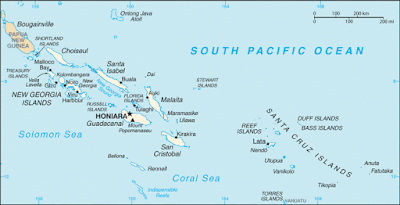
Solomon Islands is a sovereign country consisting of six major islands and over 900 smaller islands in Oceania lying to the east of Papua New Guinea and northwest of Vanuatu and covering a land area of 28,400 square kilometres (11,000 sq mi). The country's capital, Honiara, is located on the island of Guadalcanal. The country takes its name from the Solomon Islands archipelago, which is a collection of Melanesian islands that also includes the North Solomon Islands (part of Papua New Guinea), but excludes outlying islands, such as Rennell and Bellona, and the Santa Cruz Islands.
The islands have been inhabited for thousands of years. In 1568, the Spanish navigator Álvaro de Mendaña was the first European to visit them, naming them the Islas Salomón.[4] Britain defined its area of interest in the Solomon Islands archipelago in June 1893, when Captain Gibson R.N., of HMS Curacoa, declared the southern Solomon Islands as aBritish protectorate.[5] During World War II, the Solomon Islands campaign (1942–1945) saw fierce fighting between the United States and the Empire of Japan, such as in the Battle of Guadalcanal.
The official name of the then British overseas territory was changed from "the British Solomon Islands Protectorate" to "Solomon Islands" in 1975. Self-government was achieved in 1976; independence was obtained two years later. Today, Solomon Islands is a constitutional monarchy with the Queen of Solomon Islands, currently Queen Elizabeth II, as its head of state. Manasseh Sogavare is the current prime minister.
Name
In 1568, the Spanish navigator Álvaro de Mendaña was the first European to visit the Solomon Islands archipelago, naming it Islas Salomón ("Solomon Islands") after the wealthy biblical King Solomon.[4] It is said that they were given this name in the mistaken assumption that they contained great riches.[6]
During most of the period of British rule the territory was officially named "the British Solomon Islands Protectorate".[7]On 22 June 1975 the territory was renamed "Solomon Islands".[7] When Solomon Islands became independent in 1978 they retained the name. The definite article, "the", is not part of the country's official name but is sometimes used, both within and outside the country.
Kepulauan Solomon atau Kepulauan Salomo adalah sebuah negara kepulauan di Samudra Pasifik bagian selatan yang terletak di sebelah timur Papua Nugini dan merupakan bagian dari Persemakmuran. Dia terdiri dari 992 pulau yang secara keseluruhan membentuk wilayah seluas 28.450 km².
Kepulauan Solomon memiliki sejumlah pulau seperti Guadalcanal, Malaita, Santa Isabel, Makira dan Sikaiana. Jarak antara pulau paling barat dan paling timur ialah ±1.500 km.
Kapal penjelajah Spanyol Álvaro de Mendaña de Neira pertama kali mencatat tentang pulau Santa Isabel pada 7 Februari 1568. Karena adanya tanda-tanda emas di Guadalcanal, Mendaña percaya bahwa ia menemukan sumber kekayaan Raja Salomo, dan menamai pulau itu "Pulau Salomo". Pada 1595 dan 1605 Spanyol mengirim beberapa ekspedisi untuk mendiami pulau tersebut dan mendirikan sebuah koloni, namun gagal. Pada 1767 Kapten Philip Carteret menemukan kembali Santa Cruz dan Malaita. Kemudian penjelajah dari Belanda, Perancis, dan Inggris berturut-turut mengunjungi pulau-pulau tersebut; penerimaan penduduk setempat tidak ramah.
Pada 1886, Britania Raya dan Jerman membagi pulau tersebut di antara mereka. Tentara Australia lalu mengambil alih bagian yang dikuasai Jerman hingga 1920. Jepang menguasai wilayah ini antara tahun 1942 dan 1943 sebelum pihak Sekutu merebutnya.


No comments:
Post a Comment